Friday, August 22, 2014

Greenland and Antarctic maps reveal “unprecedented” ice loss


Cold as ice
Someday you'll pay the price
    - Foreigner

I have lived here before, the days of ice,
And of course this is why I'm so concerned,
And I come back to find the stars misplaced
and the smell of a world that has burned.

      -Jim Hendrix

Greetings

      Interesting goings on up in Greenland.  Ice is  melting.   (see below from Carbon Brief) This, of course is somewhat concerning, as it will "eventually" result in a problematic sea rise.

    As usual with climate science, this recent melting is proceeding "faster than anticipated".  And it seems to be accelerating.  As reported by Robert Scribbler

   "It was an extraordinary rate of melt now 4.7 times faster than in the period from 1997 to 2003 and 2.5 times faster than during 2003 to 2009. But, likely, it is but one more milestone on the path to even faster melt."
    
     What does this mean?


   Perhaps its useful to look at at the geologic record .  Here's a summary from a new report from David Spratt, author of Climate Code Red

  • "During mid-Miocene climatic optimum  [16-14 million years ago] CO2 levels were similar to today, but temperatures were ~3–6C warmer and sea levels 25 to 40 metres higher than at present… When CO2 levels were last similar to modern values (greater than 350 ppmv to 400 pmv), there was little glacial ice on land, or sea ice in the Arctic, and a marine-based ice mass on Antarctica was not viable… Lower levels were necessary for the growth of large ice mass on West Antarctica (~250 to 300 ppmv) and Greenland (~220 to 260 ppmv)" (Tripati, Roberts et al., 2009).
  • “We estimate sea level for the Middle Pliocene epoch [3.0–3.5 million years ago] – a period with near-modern CO2 levels – at 25±5 metres above present, which is validated by independent sea-level data” (Rohling, Grant et al., 2009).
  • Likewise, “during the middle-Pliocene … we find sea level fluctuations of 20-40 metres associated with global temperature variations between today’s temperature and +3°C” (Hansen, Sato et al., 2013).

 
   But of course, humans,  being creatures with hyperbolic discount rate, we aren't that concerned about events that might happen at the end of the century, but do worry about things in our lifetime.   Our first question is ; When?

     It seems the future is coming at us at an accelerating rate.   Back to Robert:

"It is likely that mass rate losses will continue to increase until some kind of break or negative feedback comes into play. Similar rates of melt increase would mean an annual 5-8 millimeter sea level rise by 2035 due to Greenland and Antarctic melt on top of a 2-3 millimeter sea level rise from thermal expansion of the oceans and from other melt sources. But even taking into account the cooling effect at the ocean surface from ice melt and fresh water floods, one could easily envision the feared 1-3 foot sea level rise by sometime near mid century and the even more concerning 3-9 foot sea level rise amidst a very intense battle between hot and cold weather systems through to century’s end."


Fun facts about sea level rise from here:

• Thirteen of the world’s 20 largest cities are now located on a coast.
• Nearly 25% of the world’s population lives within 62 miles (100 kilometers) of a shoreline, and this figure is likely to increase to 50% over the next 25 years as people flock to coastal cities.
• More than 600 million people live in coastal regions that are less than 10 meters above sea level.
• Two-thirds of the world’s cities have populations of five million or more living in at-risk areas that are less than 10 meter above sea level. (Source)
• Thirteen of the world’s fifteen largest cities are on coastal plains. Many smaller cities, such as Alexandria, Egypt’s ancient center of learning, also face a severe risk of inundation with a 39-inch (1m) rise in sea level. 
• Low-lying coastal regions in developing countries such as Bangladesh, Vietnam, India, and China have especially large populations living in at-risk coastal areas such as deltas, where river systems enter the ocean. Both large island nations such as the Philippines and Indonesia and small ones such as Tuvalu and Vanuatu are at severe risk because they do not have enough land at higher elevations to support displaced coastal populations.
• Some island nations risk the danger of losing their fresh-water supplies as sea level rise pushes saltwater into their aquifers. For these reasons, those living on several small island nations (including the Maldives in the Indian Ocean and the Marshall Islands in the Pacific) could be forced to evacuate over the 21st century. (Source)
• With sea level projected to rise at an accelerated rate for at least several centuries, very large numbers of people in vulnerable locations are going to be forced to relocate. If relocation is delayed or populations do not evacuate during times when the areas are inundated by storm surges, very large numbers of environmental refugees are likely to result. (Source)

For visual representation of such a rise see here.    

-------

Greenland and Antarctic maps reveal “unprecedented” ice loss


A series of maps published this week show Greenland and Antarctica are losing more ice than at any time since satellite records began.
Scientists found the two vast ice sheets are losing a total of 500 cubic kilometers of ice per year, contributing to rising global sea levels.
Ice loss
The researchers used data from the European Space Agency's CryoSat - a satellite that passes over the earth at 700 kilometers above the surface and measures the thickness of polar ice.
The satellite was launched in 2010 and has been collecting data on sea ice and ice sheets ever since. By comparing data with other satellite missions, scientists can see how quickly the ice sheets are changing.
The study, just published in the journal The Cryosphere, reveals that since 2009, the volume of ice loss has tripled in West Antarctica and more than doubled in Greenland. This is the highest rate of ice loss since satellite records began 20 years ago.
Regional differences
The maps show that Greenland is losing around three times more ice than Antarctica, including thinning of the entire western ice sheet and further losses in the southeast and northwest ice sheets. You can see where the greatest losses of ice are occurring in the red areas in the maps below.
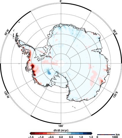
In Antarctica, the maps show thinning of the West Antarctic Ice Sheet and the Peninsula. East Antarctica shows some increases in thickness (shown in blue in the maps), though this doesn't outweigh the losses elsewhere. Overall, more ice is being lost than gained.
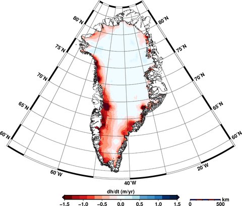
The Cryosphere _Greenland Elevation Change _Aug 14

The Cryosphere _Antarctic Elevation Change _Aug 14
Elevation changes in Greenland (top) and Antarctica (bottom) between January 2011 to January 2014. Areas in red show loss of ice; blue shows gains. Source: V. Helm et al.(2014)
Satellite measurements
CryoSat collects data at 200 million points in Antarctica and 14.3 million in Greenland, as aBBC article today notes. Satellites can measure ice sheet heights by firing a radar pulse at each point and recording the time it takes for the signal to bounce back.
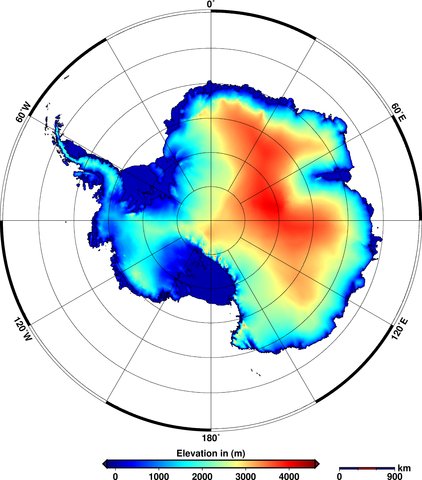
The data is used to create digital elevation models that provide a 'snapshot' of the state of the ice sheets covering the two land masses. You can see how the ice thickness varies over the surface of the earth in the figures below. The areas in red show thicker ice towards the middle of the land mass and the blue areas show the thinner ice around the edges.
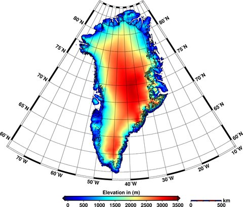
The Cryosphere _Greenland Elevation _Aug 14

The Cryosphere _Antarctic Elevation _Aug 14
Elevations of ice in Greenland (top) and Antarctica (bottom) in 2012. Red shows areas of thicker ice; blue shows thinner ice. Source: V. Helm et al. (2014)
New imagery
These aren't the only new satellite images to be released this week. A Canadian collaboration, including the University of Waterloo and the Canadian Space Agency, released a satellite 'mosaic' image of the whole of Antarctica.
The image, shown below, is made up from over 3,000 satellite images taken in 2008.
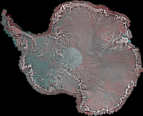
Uni Of Waterloo _Antarctica Image _Aug 14
Mosaic satellite image of Antarctica. Source: University of Waterloo
Yesterday's Mail Online covered the new research, featuring some of the satellite's images - such as the one above - including a close-up of an individual ice shelf.
The team behind the image also produced an equivalent version from images taken in 1997 and hope that being able to compare the two could help scientists identify changes in the ice sheets over Antarctica.
The next steps for the team include providing more regular updates to the Antarctic image, and creating a similar mosaic image for Greenland.

V. Helm, A. Humbert, and H. Miller (2014) Elevation and elevation change of Greenland and Antarctica derived from CryoSat-2, The Cryosphere, doi:10.5194/tc-8-1539-2014

Labels: , , , , , ,

Monday, May 26, 2014

NASA: Melt of Antarctic Glacier Unstoppable


Ice, ice, baby
  -Vanilla Ice

He feels the piston scraping --
Steam breaking on his brow --
Thank God, he stole the handle and
The train won't stop going --
No way to slow down.
   -Jethro Tull

Greetings

    I've been re-reading "Thinking In Systems"  by Donella Meadows.  It;s great stuff,  but hard on my linear thinking brain.  So, of course one of the features is self reinforcing feedback loops.    Regardless of the inputs from outside the system, they continue.    Apparently the Antarctic glaciers have sucha feedback. 

  The result ?  15 foot sea level rise.

NASA glaciologist Eric Rignot  put it this way:
“The collapse of this sector of West Antarctica appears to be unstoppable. The fact that the retreat is happening simultaneously over a large sector suggests it was triggered by a common cause, such as an increase in the amount of ocean heat beneath the floating sections of the glaciers. At this point, the end of this sector appears to be inevitable.”
   Portions of the NASA news conference are provided  courtesy of Radio Eco shock.    (see below)   Very interesting to listen to the news conference.  Several times, questioners asked something like :  "You don't really mean "unstoppable" , do you?"    And severa;l times the scientists said "Yes, We can't stop it, but we can speed it up!"


------------

Grim News From NASA: West Antarctica’s Entire Flank Collapsing Toward Southern Ocean, At Least 15 Feet of Sea Level Rise Already Locked-in Worldwide

(Must-watch NASA presentation finding six Antarctic Glaciers in irreversible collapse.)
Human-caused heat forcing. From the top of the atmosphere to the bottom of the world’s oceans, there’s no safe place to put it. For where-ever it goes it sets in place conditions with the potential to unleash gargantuan forces.
481. Minus aerosols, that’s the equivalent CO2 heat forcing humans have now built up in the atmosphere due to a constant and rapidly rising greenhouse gas emission. By itself, this heat forcing, were it to remain in the world’s atmosphere and ocean system, is enough to melt all of West Antarctica, all of Greenland, and part of East Antarctica pushing sea levels higher by between 30 and 120 feet or more.
Inertia. Namely, the massive inertia in the Earth climate system creating a perceived ability to resist rapid destabilization due to the human insult. It’s the one hope scientists and policy-makers alike pinned on the possibility of bringing human greenhouse gas emissions down in time to prevent radical and damaging change.
Rapid glacier and ice sheet destabilization. What, by 2014, became understood as the new reality, as an ever-increasing number of the world’s glaciers displayed far less resilience than previously anticipated and were set in motion to an unstoppable and catastrophic reunion with the world’s oceans by human warming.
Now, a new NASA study finds that six of West Antarctica’s largest glaciers are in a state of irreversible collapse. These add to a growing tally of destabilized glaciers from Greenland to Svalbard to Baffin Island to Antarctica and beyond which, all together, show that at least a 15 foot sea level rise from human-spurred glacial release is now inevitable.
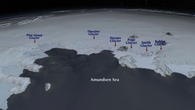
Their names were Pine Island, Thwaites, Haynes, Pope, Smith and Kohler
antarctica_screen_grab1_2
(The locations of West Antarctica’s ‘butcher board’ glaciers — those that are doomed to an inevitable embrace with the Amundsen Sea. Image source: NASA.)
At issue are six massive glaciers representing more than 1/3 of total the ice mass of West Antarctica and what could well be called its entire weak flank.
As early as 1968, this massive section of West Antarctica was listed as unstable. Since that time, human heat forcing has pumped higher and higher volumes of warmth deep into the Pacific Ocean. The warmth pooled in the depths, building, even as it rose up beneath Antarctica. Ocean circulation and Ekman pumping along the coast of Antarctica brought this warm water up from the depths where it traveled along the continental shelf zone to encounter Antarctica’s mile-high glaciers. The warm water did its work, unseen, for a time. Eating away at the bottoms of these glaciers and speeding their slide to the sea. The increased glacial melt and related fresh water outflow put a kind of cold water cap on the Southern Ocean around Antarctica. This cold cap gave the ever-warming bottom waters no outlet to the surface and so the heat concentrated where it was needed least — at the bases of massive ocean-fronting glaciers.
One section of West Antarctica, composed of the six glaciers now listed as undergoing irreversible collapse, was particularly vulnerable to this basalt melt and ocean upwelling heat forcing. For the glaciers there rested on a section of continental shelf well below sea level — extending scores of miles beneath the ice and on into interior Antarctica. As a result, newly undercut glaciers are flooded until they float, creating lift, reducing friction and rapidly speeding the glacier’s plunge seaward. Even worse, few sub-glacier ridges — speed bumps that glaciologists call grounding points — interrupt the more rapid flow of these glaciers once initiated.
(NASA slide-show illustrating the process of basal melt and grounding line retreat)
By earlier this year, a separate NASA study found that the Pine Island Glacier (PIG), one of the world’s largest glaciers and the most vulnerable ice sheet in West Antarctica, had entered a state of irreversible collapse. Now, the most recent study, led by glaciologist Eric Rignot at NASA’s Jet Propulsion Laboratory, finds that five of its fellows — Thwaites, Haynes, Pope, Smith, and Kohler — are following PIG’s lead.
Rignot’s findings could not be more stark:
“The collapse of this sector of West Antarctica appears to be unstoppable. The fact that the retreat is happening simultaneously over a large sector suggests it was triggered by a common cause, such as an increase in the amount of ocean heat beneath the floating sections of the glaciers. At this point, the end of this sector appears to be inevitable.”
In other words, over the course of decades-to-centuries, these glaciers will disintegrate and slide into the sea until they are no more. Years from now, their names will be a distant memory, reminders of a faded and far better time.
At Least 15 Feet of Sea Level Rise From Glacial Melt Now Locked-in
This year, the pace of new announcements for massive glaciers undergoing destabilization or irreversible collapse could best be described as terrifying and unprecedented. And each new announcement brings with it starker implications for both the ultimate pace and scope of global sea level rise.
Global sea level rise
(Current pace of global sea level rise at 3.26 mm per year is likely now set to rapidly accelerate coincident with the rapid acceleration and melt of an ever-increasing number of the world’s glaciers. Image source: AVISO.)
The amount of sea level rise to result from just the loss of the disintegrating section of West Antarctica described in the most recent NASA study amounts to at least four feet. But looking around the world we also find rapid destabilization of more than 13 glaciers encircling all of Greenland with one, the Zacharie Glacier, featuring an ice flow that stretches all the way to the center of the Greenland ice mass. Recent studies also find that the massive glaciers of Baffin Island and the world’s largest ice cap — the Austfonna glacier on Svalbard’s island of Nordaustlandet — are all locked in an inevitable seaward rush.
The total water composed in the moving and destabilized glaciers worldwide is now at least enough to raise world ocean levels by a total of 15 feet. But the inevitable loss of these glaciers tells a darker tale, one that hints that the 23 feet worth of sea level rise in all of Greenland’s ice and the 11-13 feet of sea level rise in all of West Antarctica’s ice may well be locked in to what is a growing daisy chain of explosive destabilization if human greenhouse gas levels aren’t radically drawn down.
In continuing to emit greenhouse gasses, we make the situation ever worse by imposing a heightening heat pressure on glacial systems that will both speed their release and ensure that an ever growing portion of the Earth’s ice ultimately melts. The current forcing though both extreme and dangerous is small compared to the potential forcing should we not rapidly reign in the human emission.
Links:
Hat tip to Peter Sinclair and Colorado Bob

-------


ANTARCTICA IS MELTING!

SUMMARY: Gasp! Antarctica is melting. Coastal cities at risk. New science direct from NASA. Plus eminent climate scientist Kevin Trenberth predicts strong El Nino impacts on world weather. Radio Ecoshock 140521

Welcome to Radio Ecoshock, I'm Alex Smith - but you won't hear much from me in this program. There is huge news from the Antarctic. Scientists fears that those glaciers will melt, lifting global sea levels above the streets of many world coastal cities - have been verified by two studies.

Later in the program, you will hear an excellent interview of top climate scientists Kevin Trenberth, conducted by Peter Sinclair.


Download this Radio Ecoshock show in CD Quality (56 MB) or Lo-Fi (14 MB)

FREE CLIMATE AUDIO QUOTES

At the bottom of this blog you can also find out about our new climate music contest, and links to download key climate quotes from Radio Ecoshock interviews. You can use these quotes for music, or in your podcast, radio show, or as audio for your web page or blog. Help yourself, help the world.

THE BIGGEST CLIMATE NEWS THIS YEAR - ANTARCTICA IS MELTING

But right now we're going to bypass the mainstream media machine to hear from the NASA scientists who say the melt of one Antarctic glacier set is now "unstoppable". We don't often get such certainty from science, or large government agencies.

This is a moment to gasp, just like the record Arctic sea ice melt of 2007. The planet has undeniably and unmistakably been altered. It's a major tipping point crossed. Even without the Greenland Ice melt, the Antarctic glaciers will reshape the geography of land for all conceivable generations to come. Redraw the maps, and realize humans will eventually withdraw from mega-cities ranging from New York to China, a retreat from the sea by millions of people, from trillions of dollars in assets. That's what this is about.

I play you an edited-for-radio replay of the NASA press conference held May 12th for the media.

Scientists have long feared that human-made climate change would trigger melting of Antarctic glaciers, especially in the fragile West Antarctic Peninsula. Now the bad news is upon us: Antarctica is melting. The process NASA scientists say, is unstoppable. The inevitable result will be massive sea level rise over the next several centuries. Some scientists suggest 7 meters, or 22 feet of sea level rise is even possible this century, but the NASA study is more conservative, as you will hear.

Keep in mind when the study authors talk about 3 meters, or 10 feet of global sea level rise, they are discussing only the potential from a small part of the West Antarctic Peninsula they have studied, not the totals from elsewhere among the South Pole glaciers, or melt waters from Greenland.


Eric Rignot

We begin with the voice of Thomas Wagner, NASA's Program Scientist for the cryosphere and Director of the agency's polar studies. He is introducing the lead scientist for this Antarctic study, Eric Rignot. Eric is Professor of Earth System Science at the University of California, Irvine. You will hear his entire presentation for the NASA teleconference, held May 12th, 2014.


Sridhar Anandakrishnan

Our next speaker at the NASA teleconference is Sridhar Anandakrishnan, Professor of Geosciences at Pennsylvania State University.

I then play you key questions from major media to these scientists and their replies. It's also an exercise in seeing what TV networks and top tier newspapers ask. You can then compare how that filters through to the public. For example, while these NASA scientists say the Antarctic glacier melt they studied IS unstoppable, the New York Times reported it MAY be unstoppable. The certainty of science did not make it to the public.

You can watch the NASA teleconference in full here.

The fact that Antarctica is committed to melting, or at least parts of the West Antarctic Peninsula are, is one of the biggest stories in years. Joe Romm, the respected energy expert and blogger at Climate Progress, says this means coastal cities in many parts of the world will ultimately be abandoned.

You can see what the United States will look like with just ten feet (3 meters) of sea level rise here.

I also recommend this short video by Peter Sinclair - "This Is Not Cool". He interviews scientists, with a couple of news clips, about huge sea level rise coming.

Mother Jones has this key article about the West Antarctic ice sheet collapse.

You can get more essential facts from this Washington Post article.

EAST ANTARCTICA ALSO AT RISK OF MELTING

But it's not just the West Antarctic peninsula, although that will go first. New science finds East Antarctica, long thought impervious to near-term climate change, is also at risk of melting.

TWENTY TWO FEET OF SEA LEVEL RISE BY 2070?

The most extreme prediction comes when University of Ottawa climate scientist Paul Beckwith asks whether we could see 7 meters of sea level rise (22 feet!) by 2070. Find that in this You tube video. Paul also points out that moving massive amounts of water from land-based glaciers to the oceans could destabilize weak spots in the Earth's crust, leading to more seismic activity (read deadly earthquakes and tsunamis).

You can read Peter Sinclair's blog article about important New York Times coverage of this Antarctic melting news, plus references to the original science, here.

Unfortunately, one of the original scientific papers is behind a pay wall. Here is the linkanyway.

Labels: , , , ,

Sunday, April 28, 2013

Ice, Ice, Baby!


Greetings

     Here  is an interesting interview with Prof Peter Wadhams, and expert on sea ice, and a review editor for the IPPC.    He discusses the problems with the current models, and some of limits to the IPCC process.  He discusses the likely end of summer ice, the impact of methane and the likelihood of Southern Europe turning in to a desert in this century! 
 
      He is somewhat critical of government policy offices for their reliance of the models, and apparent ignoring the actual observations.

   Just discovered Nevin's Sea Ice Blog.  Quite Amazing.  Lot's of video Interviews with sea ice scientists.  Really good stuff.

Dr Jennifer Francis's article in Yale 360  linking weird weather with the changes in jet stream, caused by the warming in the Arctic.
    
Her article in Oceanography linking Super Storm Sandy to the Arctic, and the jet stream

Jeff Masters's blog about the jet stream and the odd spring weather - second most extreme March.

Death Spiral Video   Help it go viral

The Dark Snow Project  a crowd funded research project to find out how much does wildfire, and industrial soot contribute to Greenland melting


See also:   Paul Bekwith,s blog:   


UPDATE: NEW NASA SATELLITE IMAGERY


By Paul Beckwith
The Arctic region of our planet acts as a climatic air conditioner, and the air conditioner is conking out. We have a problem Houston.
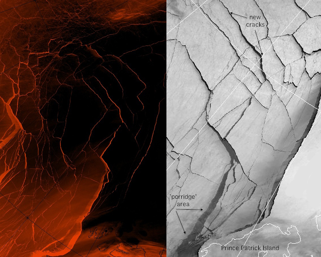
Over the past few weeks, massive cracks have appeared in the ice that connects the Beaufort Gyre region to Alaska. As a result of last summer’s record sea ice-loss, the winter ‘refreezing’ process went dismally and the surface area and thickness never recovered. The situation is frightening with the beginning of the 2013 melt season only a few weeks away.
Policymakers and governments around the world are still using outdated climate models and are therefore operating under faulty presumptions. The best example of this is their maintaining that the Arctic will retain sea ice until sometime between 2040 and 2070, ignoring the devastating 2012 summer loss of sea ice (roughly 30%!). For the record, they’re wrong - completely wrong! Six to 30 months is a much more likely scenario. Maintaining this naïve assumption will not only go down in history as colossal climatology #FAIL, it’s dangerous as it lulls people into a false sense of security (and atmosphere of non-urgency). It facilitates non-action, plain and simple. And we need action now.

HANG ON FOLKS

What does this mean for the planet? If you’ve followed my previous blogs over the past year, you know that as the sea ice and snow cover declines, strange things start happening to jet streams. Very strange. They slow down, become much wavier and more unpredictable (like Frankenstorm Sandy taking a left instead of right), and are directly responsible for an increase in the frequency, size and severity of extreme weather events (floods, heat waves, droughts, etc.). Climate refugees, global disruption of agriculture, growingly-extreme weather events and phenomena… unless we act soon the future is certainly grim.

As is usual these days, the best and most accurate up-to-date information on the state of Arctic sea ice is obtained from climatology blogs and a wealth of online data sources (if you want to look for it, that is). Uncensored near-real-time data and images of sea ice thickness, concentration, motion, temperature and just about anything else you can measure can be found here and here. For example, here's the movie showing how the sea ice thickness has decreased over the past year. The state of deterioration is clear (and shocking).

So back to those new Arctic icecap cracks developing… everything you need to know can be found here. Even better than the images and the article itself, in my opinion, are the comments from climatologists, scientists and a growing number of very informed amateurs from around the world. These folks are very knowledgeable about Artic sea ice; many of them have followed the disappearing Artic sea ice for years and are clearly a step ahead of most scientists in their field (at least those scientists not following the links above!). It’s these folks who first spotted the cracking and raced to archival satellite imagery (from 2012) to confirm their fears. Turns out those cracks are appearing 51 days earlier than they did last year. That’s a staggering revelation and a game-changer (NOT a good one) as we approach the 2013 melt season.

As I wrote before: Hold on folks… the times they are a-changin’.

Paul Beckwith is a PhD student with the laboratory for paleoclimatology and climatology, department of geography, University of Ottawa.

Labels: , , , ,