Early May heat dome. A four word combination that may as well be a curse. And not something we would typically expect well before the height of summer. But that’s exactly what’s happened to the US from the southwest and on to its Heartland under a merciless regime of heat and drought fed by human-caused climate change.
As of Sunday, a high amplitude Jet Stream wave had formed over the Central US. The brief up-slope was enhanced by a number of unstable and powerful atmospheric dynamics. To the southwest, a warming Eastern Pacific lent energy from a growing pool of heat. To the north, from Arizona, to New Mexico, to Texas, to Oklahoma, lands baked by more than a decade of chronic drought provided almost no evaporative cooling as the atmospheric heat lens came into dangerous, greenhouse gas enhanced focus far overhead.
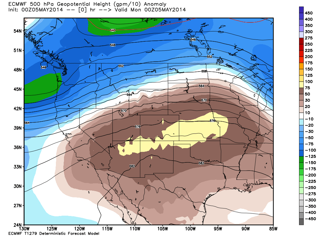
(ECMWF pressure anomaly graphic from
Weatherbell Analytics showing a strong heat dome in place on Monday May 5, 2014.)
To the North, Wichita Kansas shattered its all-time record high temperature by a whopping 8 degrees spiking to an extreme of 102 F. Not only was the heat far stronger than normal. It came far earlier. For Wichita, the earliest 101 F or greater reading came on June 4 of 1933 with most years waiting until late June or early July for 100 F + readings.
For the Heartland, this flash heatwave was very much like the heat of July coming far too early. Across Oklahoma, multiple wildfires erupted from lands ravaged by the most recent event in a long spate of ever-increasing heat and dryness. The rapid rash of burning occurred in regions near homes and businesses forcing more than a thousand to flee.
This sudden, extreme and profound heat prompted Gary McManus, Oklahoma’s state climatologist to write: “Oklahoma is burning, both literally and figuratively, as a combination of drought, record heat, high winds and low relative humidity created the perfect wildfire conditions yesterday,” in
the Oklahoma Climatological Survey’s online Ticker.
By early Tuesday, more than 30 structures were destroyed, one soul was lost, and over 6,000 acres had been consumed throughout the state. Though the fires of Sunday and Monday were mostly contained, conditions throughout the state remained hot, dry and dangerous with many more high temperature records expected to fall by late Tuesday afternoon. Mid-morning temperatures in many locations had already risen to the mid to upper 80s and more daily highs in the 90s and 100s were expected throughout the region.
Oklahoma governor Mary Fallin issued burn bans for almost half the state as firefighters predicted continued extreme fire potentials for the state throughout the week.
USDA issues Dust Bowl Warning
Meanwhile, US Department of Agriculture officials issued a warning Tuesday that conditions in the US Heartland were rapidly deteriorating along lines last seen during the infamous 1930s Dust Bowl as expectations for the US domestic winter wheat crop again fell after the USDA’s most recent agricultural tour.
Even prior to the extreme early May heatwave emerging over the Central US Sunday, Monday and Tuesday, the percent of the US wheat crop in either good or excellent condition had fallen another 2% to 31% late last week. Meanwhile, crops listed as ‘very poor’ rocketed from an already abysmal 34% to 39% over the same period. The net result is that the US wheat crop is in its worst condition since at least 1996, according to findings by Commerzbank analysts.
For Oklahoma, at the epicenter of current agricultural harm and flash heatwaves, only 6% of the state’s entire wheat crop was listed as in either good or excellent condition.
Department of Agriculture crop scouts described the Oklahoma situation in, perhaps, the starkest possible terms during their most recent report stating:
“Producers in the Panhandle continued to experience high winds … and low moisture conditions similar to the Dust Bowl in the 1930s.”
Overall, analysts now expect a US wheat crop of just 762 million bushels, the third lowest in 15 years despite record areas planted.
Conditions in Context
(Greatly diminished Sierra Nevada snow pack as seen from satellite on May 4, 2014. Image source:
LANCE-MODIS.)
In addition, a developing El Nino in the Eastern Pacific is likely to enhance already dry conditions over the US Heartland through the summer months. Together with the firmly re-entrenched west coast blocking pattern, conditions associated with El Nino set in place an extreme risk for a highly damaging return to drought for large sections of the United States this summer.
Globally, droughts continue to impact a number of the world’s previously most productive agricultural regions. In particular, both Brazil and India are currently suffering from extreme heat and/or drought. Argentina, one of the world’s top wheat producers is also hard-hit. Another one of the world’s largest grain exporters — the Ukraine — has recently been destabilized by a series of ills including east-west geopolitical tensions, internal division, and by Russian invasion. In this context, it is also worth noting that drought, fire, and flood have reduced Russian wheat production from 61 million tons in 2009 along a declining scale to 38 million tons in 2012.
Damages and risks to US crops are, therefore, not simply a national phenomena, but part of a much larger global context of ongoing and increasing crop damage due to extreme weather set off by human-caused climate change.
Links:
Hat tip to:
Colorado Bob
Todaysguestis
Jay M.


0 Comments:
Post a Comment
Subscribe to Post Comments [Atom]
<< Home